Trail Walking Les Hauts-de-Caux - Les trois Tots - Photo

Club Rando Saint-Paër

© OpenStreetMap contributors
Length
Length
12.8 km
Max alt
Max alt
157 m
Uphill gradient
Uphill gradient
95 m
Km-Effort
Km-Effort  
14.1 km
Min alt
Min alt
127 m
Downhill gradient
Downhill gradient
95 m
Boucle
Boucle
Yes
Creation date :
2023-01-21 10:07:13.947
Updated on :
2023-01-21 10:08:33.771

(2 Reviews)

Walking
Walking
3h12
Difficulty : Medium

Scan this QR Code to open this trail in the SityTrail application

FREE GPS app for hiking

Logo SityTrail SityTrail

IGN / Geographical institutes

Download SityTrail from the App Store Download SityTrail from Google Play

Logo SityTrail SityTrail World

The world is yours!

Download SityTrail from the App Store Download SityTrail from Google Play Download SityTrail on Huawei AppGallery

About

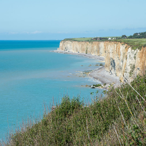
Trail Walking of 12.8 km to be discovered at Normandy, Seine-Maritime, Les Hauts-de-Caux. This trail is proposed by BOUSSOLE ET SAC A DOS.

Elevation profile

Positioning

Country:
France
Region :
Normandy
Department/Province :
Seine-Maritime
Municipality :
Les Hauts-de-Caux
Location:
Unknown
Start:(UTM)
338550 ; 5502568 (31U) N.

Comments

Please log in to post a review or rate the element


OK 👌


Trails nearby

Trail On foot Ectot-lès-Baons - Circuit d'Ectot-les-Baons - Relais du Gal - Photo
On foot
PRO

On foot

Easy
Ectot-lès-Baons, Normandy, Seine-Maritime, France
6.7 km | 7.2 km-effort
1h 37min
No
Trail Walking Héricourt-en-Caux - hericout hoherville - Photo
Walking
RoMo

Walking

Medium
Héricourt-en-Caux, Normandy, Seine-Maritime, France
11.4 km | 14.1 km-effort
2h 38min
Yes
Trail Other activity Héricourt-en-Caux - Sur les pas de Jehan le Povremoyne - Héricourt-en-Caux  - Photo
Other activity
tracegps

Other activity

Medium
Héricourt-en-Caux, Normandy, Seine-Maritime, France
9.8 km | 11.6 km-effort
1h 30min
Yes
Trail Walking Héricourt-en-Caux - Sur les pas de Jehan le Povremoyne - Héricourt-en-Caux  - Photo
Walking
tracegps

Walking

Medium
Héricourt-en-Caux, Normandy, Seine-Maritime, France
9.8 km | 11.6 km-effort
2h 30min
Yes
Trail On foot Étoutteville - La voie romaine - Photo
On foot
PRO

On foot

Easy
Étoutteville, Normandy, Seine-Maritime, France
7.2 km | 8.2 km-effort
1h 51min
Yes
Trail Walking Écalles-Alix - 076-06-Écalles-Alix 19.5km-738-807  - Photo
Walking
rvs147

Walking

Medium
Écalles-Alix, Normandy, Seine-Maritime, France
19.3 km | 23 km-effort
4h 57min
Yes
Trail Walking Héricourt-en-Caux - hericourt en caux - Photo
Walking
nicole.reine@wanadoo.fr

Walking

Difficult
Héricourt-en-Caux, Normandy, Seine-Maritime, France
10.4 km | 12.2 km-effort
2h 44min
Yes
Trail Hybrid bike Yvetot - Au fil de la Risle - Photo
Hybrid bike
ves

Hybrid bike

Medium
Yvetot, Normandy, Seine-Maritime, France
178 km | 208 km-effort
Unknown
No
Trail Walking Yvetot - Les Fonds de Saint-Clair - Photo
Walking

Walking

Easy
Yvetot, Normandy, Seine-Maritime, France
13.7 km | 15.7 km-effort
3h 27min
Yes


Close
My subscriptions